Out of Norm Travels - Iceland The Land of Contrasts
As I wrote this, I had already finished my last bits of Skyr, Iceland's famous low fat yogurt and with that last bit, all my lovely memories from a land I had visited in early February 2016 started flooding back.
This land is located some 12,680 km/7,878 miles away from home and took me some 16+ hours over 2 airlines before I finally landed on Keflavik International Airport, Iceland's international airport located in Reykjavik, which is also Iceland’s capital. Reaching Iceland has been nothing short of a dream with my travel into extreme cold where "normal" means 0 degrees or less.
For me, Iceland is a country of contrasts where Fire meets Ice, Water claps hands with the Earth, Skies says hello to the Earth and the Land where Giants, Trolls and Elves used to roam.
Our travels across this vast land first brought us towards Kirkjufell (West Iceland) on the north side of the Snæfellsnes Peninsula where we encountered the mighty Kirkjufell Mountain standing at 463m high with its distinctive cone shape. Kirkjufellsfoss Waterfall is the location setting for Jules Verne’s beloved “Journey to the Center of the Earth,”. Staying here for 2 nights proved fruitful as the auroras peaked out from the clouds above for both nights. Here’s my ‘Skies saying hello to Earth’ moment at

A further drive up to the Buðir black church was worth it as this church is one of the 3 black churches in Iceland. Dating back from the 18th century on the southern edge of the Snæfellsness peninsular, this place is surrounded by the Búðahraun lavafield, rumored to be home to countless elves. It is impressive with its exterior wood painted with pitch (like the hull of a boat to protect it from the harsh Icelandic elements) and surrounded by an unusual wall made of lava and topped with turf which is particularly picturesque when viewed from the adjoining graveyard with the majestic Snæfellsnes mountain range as its backdrop.

I encountered my first Giant story in this part of Iceland where the saga of Bäröur Snæfellsás (deity of Mount Snæfells) is told. It was said that Bäröur was descended from Giants and men. Barour is the son of a King from Northern Hellaland in Scandinavia. He staked claim to the land of Laugabrekka by the glacier at the end of the 19th century. Later in life, Barour' giant nature became more apparent. In the end he disappeared into Snæfell glacier but he did not die. He became a nature spirit and the local folk around the glacier petitioned him for matters big and small.

My ‘Water Claps Hands with Earth’ moment was when I first saw the Gullfoss also known as the Golden Falls. Together with Þingvellir (where the effects of two major tectonic plates drifting apart can easily be observed above sea level) and the Geysir (where the word ‘Geyser’ originated) of Haukadalur, Gullfoss forms the Golden Circle, a popular day tour for tourists in Iceland. The Gullfoss waterfall is located in the canyon of Hvítá river in southwest Iceland. About a kilometre above the falls the waters turn sharply to the right and flow down into a wide curved three-step "staircase" and then abruptly plunges in two stages (11 m and 21 m) into a crevice 32 m (105 ft) deep. The crevice, about 20 m (60 ft) wide, and 2.5 km in length, extends perpendicular to the flow of the river. It is said that the average amount of water running over this waterfall in wintertime is around 80 m³/s. As one first approaches the falls, the crevice is obscured from view, so that it appears that a mighty river simply vanishes into the earth. The waterfall was frozen over when we reached there for sunset although parts of it still visible. One theory about the name says that there was an old farmer named Gygur from Gygarholl who had plenty of gold and could not bear the thought of someone else getting it after his death. To prevent this, he placed the gold in a coffer and threw it into the waterfall - which ever since has been known as Gulfoss.

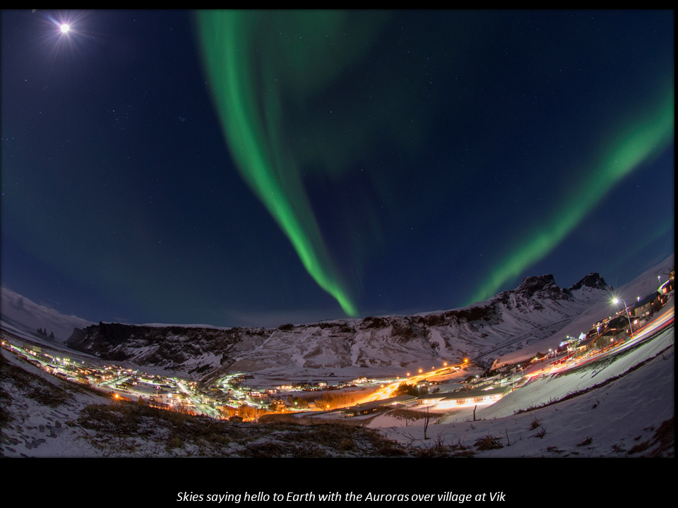
The Troll story that I encountered was at the Black Beach located in the village of Vík (or Vík í Mýrdal in full). Located in the southernmost village in Iceland, it is located on the main ring road around the island. Viks’ famous sea stacks which are rock columns made of basalt sticking out of the sea called Reynisdrangar. These columnar basalt creations are rather impressive and according to legend, the Reynisdrangar needles are the remains of 2 night-trolls, who tried to pull a three-masted ship to land. But they were caught by the dawn and when daylight broke they turned into stone. Here’s some photos of this impressive rock formation, far and up close with the waters of the Atlantic rolling in here with full force because there is no landmass between here and Antarctica.


The town's church, located high on a hill, is believed to be the only building that would survive a flood that is triggered by the nearby Katla volcano. Our 2 nights were well spent at Vik as i managed to capture my first 'aurora over village' shot with the village enveloped by the auroras above. We had this wonderful scene for a good hour or so before the cloud cover came along.
My “Fire meets Ice” moment was at Jokulsarlon beach, a black sand beach that is formed from a volcanic rock and is usually filled with crystal clear icebergs that are washed up from the sea. When the sunlight hits the icebergs at sunrise or sunset, the sky light simply illuminates the icebergs that lies on the pitch black sand.

Interesting facts regarding this special country:
- Iceland is an island that lies in the north of the Atlantic Ocean that just touches the Arctic Circle.
- It is one of the most volcanic regions in the world with more than 13% covered by snowfields and glaciers.
- With widespread availability of geothermal power, and the harnessing of many rivers and waterfalls for hydroelectricity, Icelanders have access to inexpensive hot water, heating and electricity.
- The water from the tap is good for drinking as their water is either harnessed from the ground or from the rivers and waterfalls nearby.
- Most people live in the 7% of the island that is made up of fertile coastland with almost half of its entire population living in Reykjavik, its capital.
- It is prudent to check the weather forecast and road conditions every day before starting any drives from location to location. For us, we easily encountered snow, rain, hail and sleet and of course bright sunshine over a 2-4 hour drive from location to location. Iceland weather can be accessed via http://en.vedur.is/ and road conditions via http://www.road.is/ .
- The wind factor whilst we were there averaged around 40km/h with one particular day having winds of 93km/h (!) Average temperatures were between 0 (32 °F) to -4 degree Celsius as it was winter time although the real-feel temperature varies more widely (mainly due to the wind factor).
Till the next time, onto the world and beyond!


Comments
Post a Comment